 Port Credit Marine Survey & Yacht Delivery |
9. Reading The Water |
| I have taken hundreds of photographs of currents
and eddies trying to illustrate a few
of
the following points but I am not enough
of a photographer to do a good job
catching
the subtleties of these with a digital
camera
(or any other kind), but I do have
a few
shots that may help along with a couple
of
diagrams. With some practice you should almost always
be able to sight the deeper water in
a current.
Whether it is deep enough is another
matter.
The river - Mark Twain once made a living as a Mississippi River pilot and the river pilots of today although backed up by many other methods still heavily rely on their local knowledge of a particular river and an understanding of river dynamics and how they affect underwater topography. I do not claim to be an expert in this field however I do remember high school geography classes on river formation and I am a fairly observant person. If I was really good at this I would be making $200k working 8 days a month as a river pilot but I do have a few tips. The key to successful river or inlet cruising is observation and continual learning. River Basics -The chart at right shows the primary factor of concern to boaters.
|
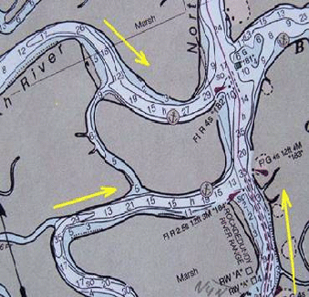 |
| As a river bends, centrifugal force causes
the bulk of the current to scour a
deeper
channel on the outside of the curve.
The deeper water is almost always at the
outside of a bend. The slower moving
water
on the inside of the curve is more
easily
affected by shore and bottom friction
thereby
causing back eddies which deposit silt
on
the downstream inside of the curve. This is complicated
somewhat by river currents being opposed
by tidal currents but is generally
true.
The Yeocomico River shown below is a good example of this phenomena.
The above water topography also gives
clues
to what may be under water. If there
are
high banks on one side of a river and
low
banks on the other, the high banks
have likely
been eroded by faster and therefore
deeper
water. The low sloping bank marked
by yellow
dots continues about 75 yards into
the river
where water is 2’ deep. The black dotted
line shows the path of the boat going
downstream,
hard against the far high bank in 18’
of
water on the outside curve. |
|
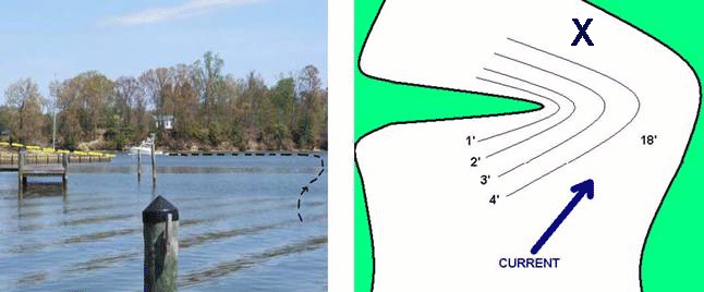 "X" Shows position of the boat in the photo |
|
|
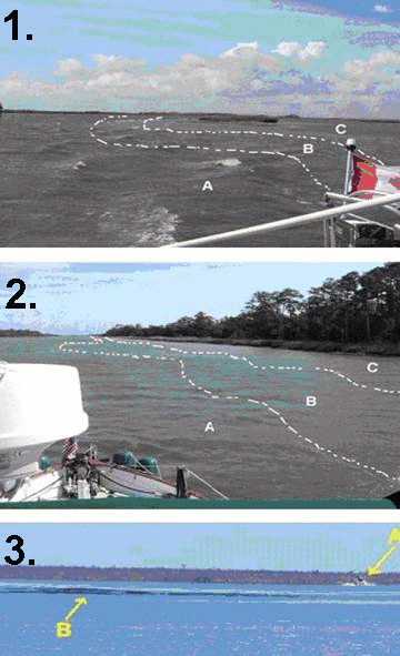
When traveling in 12’ of water with a light chop, a still patch probably indicates a shallow spot as the friction with the shoal slows the water down. When passing close by a shallow spot, the water accelerating around it may give your boat a little push to one side. If you over correct (natural reaction) you may run into the bank. Photo 1. Section A shows moderately rough water therefore faster and deeper. Section B shows the transition area between deep & shallow where faster and slower water fight each other. Section C shows relatively still water indicating a shallow bank. Photo 2. Same thing but more subtle in this shot.
Close observation of surface effects
will
go a long way to keeping you off the
shoals. Unlike the Bahamas or the keys, until you are well into Florida the water is largely opaque and the colour of the water tells you little about what’s under the surface. The water here was so still and opaque that
without the wake of the distant boat
(A)
which passed us two full minutes before this
shot was taken) shown hitting a shoal
at
point (B) we may not have seen the bank. Need a marine surveyor in Ontario... See this list of Every Marine Surveyor in Ontario  |
 |